The Four Corners:
The Four Corners Monument stands as a unique quadripoint on the U.S. landscape, marking the precise intersection of the southwestern corner of Colorado, the southeastern corner of Utah, the northeastern corner of Arizona, and the northwestern corner of New Mexico. It holds the distinction of being the only point in the United States shared by four states, making it one of the most famous surveyed monuments in the country.
However, on April 19, 2009, the monument's location came under scrutiny when a story, initially reported by local journalist Lynn Arave in Utah's 'Deseret News' and picked up by major news networks, claimed that the Four Corners marker was inaccurately placed. Arave, relying on Google Earth measurements and geocaches, asserted that the monument was 1,500 feet off, sparking controversy. In response, Randy Zanon, the Chief Cadastral Surveyor for the BLM Denver Office, unequivocally stated that the monument marked the exact point of intersection of the state lines.

A somewhat daunting welcome to the Navajo Nation; a sign exhibiting twenty-five large-caliber bullet holes as a greeting!
The Lynn Arave article erroneously claims that the intended location of the Four Corners Monument was 109° West longitude and 37° North latitude, aligning with the current position on Google Maps. However, this assertion is incorrect. The discrepancy, rooted in a misunderstanding of history, harks back to the monument's origins in 1863. An Act of Congress, signed by President Lincoln, delineated the dividing line between Arizona and New Mexico, specifying that it should coincide with the 32nd Meridian of longitude west of Washington, D.C.
In 1868, the United States General Land Office (GLO), the precursor to the Bureau of Land Management (BLM), commissioned Ehud Noble Darling to survey the 37° North latitude, as mandated by the Act of 1864. This delineation marked the south boundary of Colorado. Subsequently, in 1875, Chandler Robbins, under contract from the GLO, surveyed the entire border between Arizona and New Mexico territories. His directive included establishing the Four Corners monument, specifically setting the quadripoint at 32° West longitude on the 'Darling line' of 37° North latitude, which served as the southern boundary of Colorado.
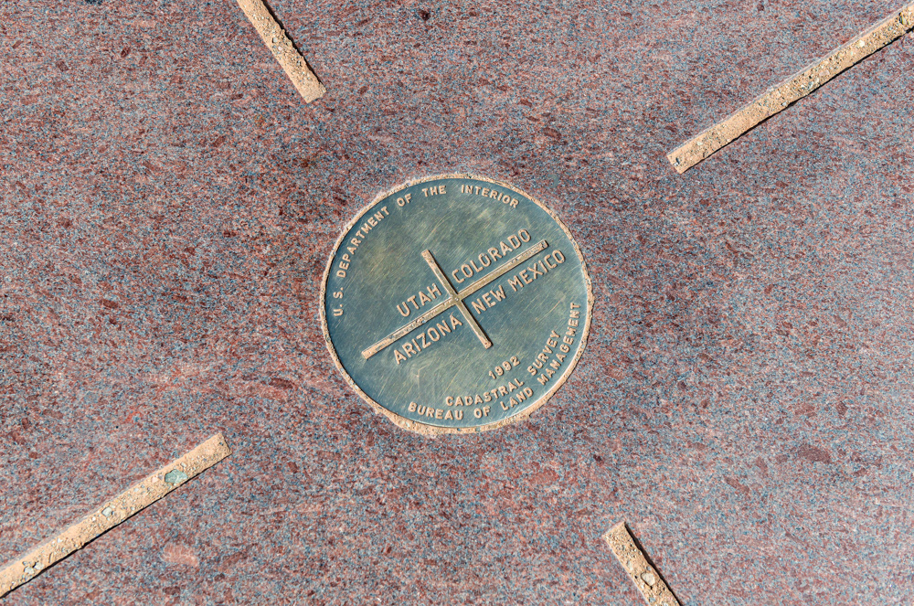
The unique four corners quadripoint, the only point in the United States where four states meet, is located at 32° WEST longitude and 37° NORTH latitude.
What Arave overlooked in his assertions is the historical context of the Prime Meridian. The Greenwich Meridian, currently used by Google Earth and measured from 109° west, was not accepted as the Prime Meridian by the United States until 1912. In 1884, U.S. President Chester Alan Arthur convened the International Meridian Conference in Washington, D.C., with delegates from 25 countries. The conference aimed to select a global Prime Meridian, and the Greenwich Meridian was chosen due to the superiority of British shipping and nautical charts based on Greenwich, widely used by most countries.
Prior to this decision, each government established its own Prime Meridian for measurements within its borders. In the expansion of the United States, four different Prime Meridians were employed. Charles Pierre L'Enfant proposed the first, bisecting the Capitol Building, but Congress never implemented it. Thomas Jefferson suggested the second, establishing a Prime Meridian at the right-angle point of a triangle drawn between the White House and the Capitol Building. Congress agreed, and this Meridian was in use until 1850. Subsequently, in 1850, the Meridian shifted to the old U.S. Naval Observatory near the U.S. Capitol, with longitudinal measurements taken from its dome. The final shift occurred in 1893 when the new U.S. Naval Observatory in northeast D.C. was completed, and the Prime Meridian moved to its new dome. In 1912, all measurements were standardized to Greenwich as the global standard for longitude reference.

The Four Corners quadripoint, on one of those rare occasions, it's not overwhelmed by tourists.
The crucial outcome is that the Chandler Robbins quadripoint was established based on the U.S. Prime Meridian, which intersected the dome of the old Naval Observatory at 32° West longitude. Importantly, this did not align with 109° West from Greenwich. The boundaries of eleven western states were similarly longitude-referenced to the Washington Meridian, not the Greenwich Meridian. In 1925, the Supreme Court rendered a decision affirming that all states had accepted the markers placed during the initial surveys in 1864 and 1875. As a result, these markers, including the Four Corners Monument, defined the actual borders and held legal binding status.
Sources:
Wikipedia contributors. (2022, October 27). Four Corners Monument. Wikipedia. https://en.wikipedia.org/wiki/Four_Corners_Monument